
AI that automatically detects methane plumes from space could be a powerful tool in combating climate change.
University of Oxford researchers, in partnership with Trillium Technologies’ NIO.space, have developed a tool to automatically detect methane plumes on Earth from orbit using machine learning with hyperspectral data. This could help identify excessive ‘super emitters’ of methane and enable more effective action to reduce greenhouse gas emissions. The findings have been published in the journal Nature Scientific Reports.
What makes this research particularly exciting and relevant is the fact that many more hyperspectral satellites are due to be deployed in the coming years, including from ESA, NASA, and the private sector. In combination, these new sensors will provide global hyperspectral coverage, enabling worldwide automated detection of methane plumes.
Lead researcher DPhil student Vít Růžička (Department of Computer Science, University of Oxford)
Although Net Zero targets focus on CO2 emissions, combating methane emissions is also a critical activity to slow rising temperatures. Methane is 80 times as effective in trapping heat as CO2, but has a much shorter atmospheric lifetime (around 7 to 12 years compared to centuries). Acting quickly to reduce methane emissions from anthropogenic sources would therefore have an immediate impact on slowing global heating and improving air quality. It has been estimated that readily achievable methane emission reductions could deliver nearly 0.3° C of avoided warming over the next two decades.
Until now, however, there have been only very few methods to readily map methane plumes from aerial imagery and the processing step is highly time-consuming. This is because methane gas is transparent to both the human eye and the spectral ranges used in most satellite sensors. Even when satellite sensors operate in the correct spectral range to detect methane, the data is often obscured by noise, requiring laborious manual approaches to effectively identify the plumes.
A new machine-learning tool developed by Oxford researchers overcomes these issues by detecting methane plumes in data from hyperspectral satellites. These detect narrower bands than more common multispectral satellites, making it easier to tune to the specific signature of methane and filter out noise. However, the amount of data they produce is much larger, making it challenging to process without artificial intelligence (AI).
The researchers trained the model using 167,825 hyperspectral tiles (each representing an area of 1.64 km2) captured by NASA’s aerial sensor AVIRIS over the Four Corners area of the USA. The algorithm was then applied to data from other hyperspectral sensors in orbit, such as data collected from NASA's new hyperspectral sensor EMIT (Earth Surface Mineral Dust Source Investigation mission) which is attached to the International Space Station and provides near global coverage of the Earth.
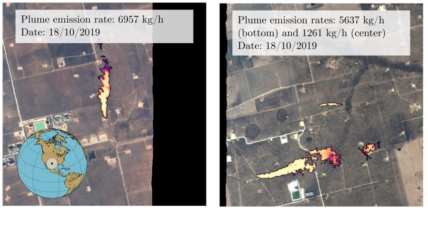 Model predictions of methane leaks using data from the AVIRIS aerial mission flown above the Four Corners area in the USA in 2019. Image credit: Open source AVIRIS data (NASA) processed by Vít Růžička.
 Overall, the model has an accuracy of over 81% for detecting large methane plumes*, and was 21.5% more accurate than the previous most accurate approach. The method also had a significantly improved false positive detection rate for tile classification, lowering it by about 41.83% in comparison with the previous most accurate approach.
To promote further research in methane detection, the researchers have open sourced both the annotated dataset and the code used for the model on the project page at GitHub. They are now exploring whether the model could operate directly onboard the satellite itself, allowing other satellites to conduct follow-up observations as part of the NIO.space initiative.
In the face of climate change, these kinds of techniques allow independent, global validation about the production and leakage of greenhouse gases. This approach could easily be extended to other important pollutants, and building on earlier work, our ambition is to run these approaches on-board the satellites themselves, making instant detection a reality.
Professor Andrew Markham (Department of Computer Science), supervisor for the research
Lead researcher DPhil student Vít Růžička (Department of Computer Science, University of Oxford) said: ‘Such on-board processing could mean that initially only priority alerts would need to be sent back to Earth, for instance a text alert signal with the coordinates of an identified methane source. Additionally, this would allow for a swarm of satellites to collaborate autonomously: an initial weak detection could serve as a tip-off signal for the other satellites in the constellation to focus their imagers on the location of interest.’
The project was funded by the European Space Agency (ESA) Φ-lab via the ‘Cognitive Cloud Computing in Space’ (3CS) campaign and conducted as part of the Trillium Technologies initiative Networked Intelligence in Space (NIO.space).
The paper ‘Semantic Segmentation of Methane Plumes with Hyperspectral Machine Learning Models’ has been published in Nature Scientific Reports.
* The model has an F1 score of 81.96 points (out of possible 100) for detecting large methane plumes.
 Landmark study definitively shows that conservation actions are effective at halting and reversing biodiversity loss
 Researchers find oldest undisputed evidence of Earth’s magnetic field
 Honorary degree recipients for 2024 announced
 Vice-Chancellor's innovative cross-curricular programme celebrated
 New database sheds light on violence in Greek detention facilities